|
|
|

Японская иллюстрированная карта Первой мировой войны. 1914
The Illustration of the Graet (sic) European War. 1914
Примечания к карте (Asia Bookroom, 2022)
Опубликованная сразу после начала Первой мировой войны, 13 сентября 1914 года, с английским подзаголовком ‘The Illustration of the Graet European War’ [sic] («Иллюстрация Великой европейской войны» с ошибкой в слове "Great"), эта карта была разработана и напечатана Танака Рёдзо (Tanaka Ryōzō; 1874—1946), который владел типографией в центре Токио и позже стал хорошо известен благодаря выпуску репродукций работ выдающихся художников-ксилографов. Хотя в подзаголовке карты указано, что это «карта мира», на самом деле это карта Европы, Азии и части Северной Африки.
США (см. правый нижний угол карты) изображены в виде человека в шляпе, который смотрит на Азию через телескоп с небольшого участка земли, находящегося, по-видимому, где-то в середине Тихого океана. Остальные части Северной и Южной Америки, а также Австралия и Новая Зеландия отсутствуют.
Красочно иллюстрированная карта искусно изображает каждую страну в виде животного или, реже, в виде человеческой фигуры, давая интригующее представление о японских представлениях о состоянии мира (и некоторых японских предрассудках относительно соседних стран!) в начале Первой мировой войны. По условиям союза с Великобританией Япония вступила в войну на стороне союзников, и ее отношение к Германии и Турции как к врагам отражено в изображении Турции в виде тигра и Германии в виде дикого кабана с саблей, которого пронзают стрелы с надписями ‘France’ («Франция»), ‘Gritain’ [sic] (опечатка в слове "Britain" — «Британия»), ‘Japan’ («Япония») и ‘Russia’ («Россия»). Но другая главная центральная держава, Австро-Венгрия, представлена довольно размытым изображением собаки, что наводит на мысль о том, что, возможно, иллюстратор карты не имел четкого представления о природе империи Габсбургов.
Тем временем Франция, похоже, поглощена немецким кабаном, а Британия изображена в виде сясихоко — мифического морского чудовища с телом карпа и головой тигра, обычно используемым в качестве украшения на крышах японских зданий (Ирландия либо отсутствует на карте, либо, возможно, представлена одним из плавников сясихоко).
The Illustration of the Graet (sic) European War. 1914. Detail: Great Britain
Доминирующими фигурами на карте являются Россия — изображенная в виде очень большого сонного медведя, курящего трубку, и Китай — в виде свиньи, которая довольно загадочно смотрит на барометр.
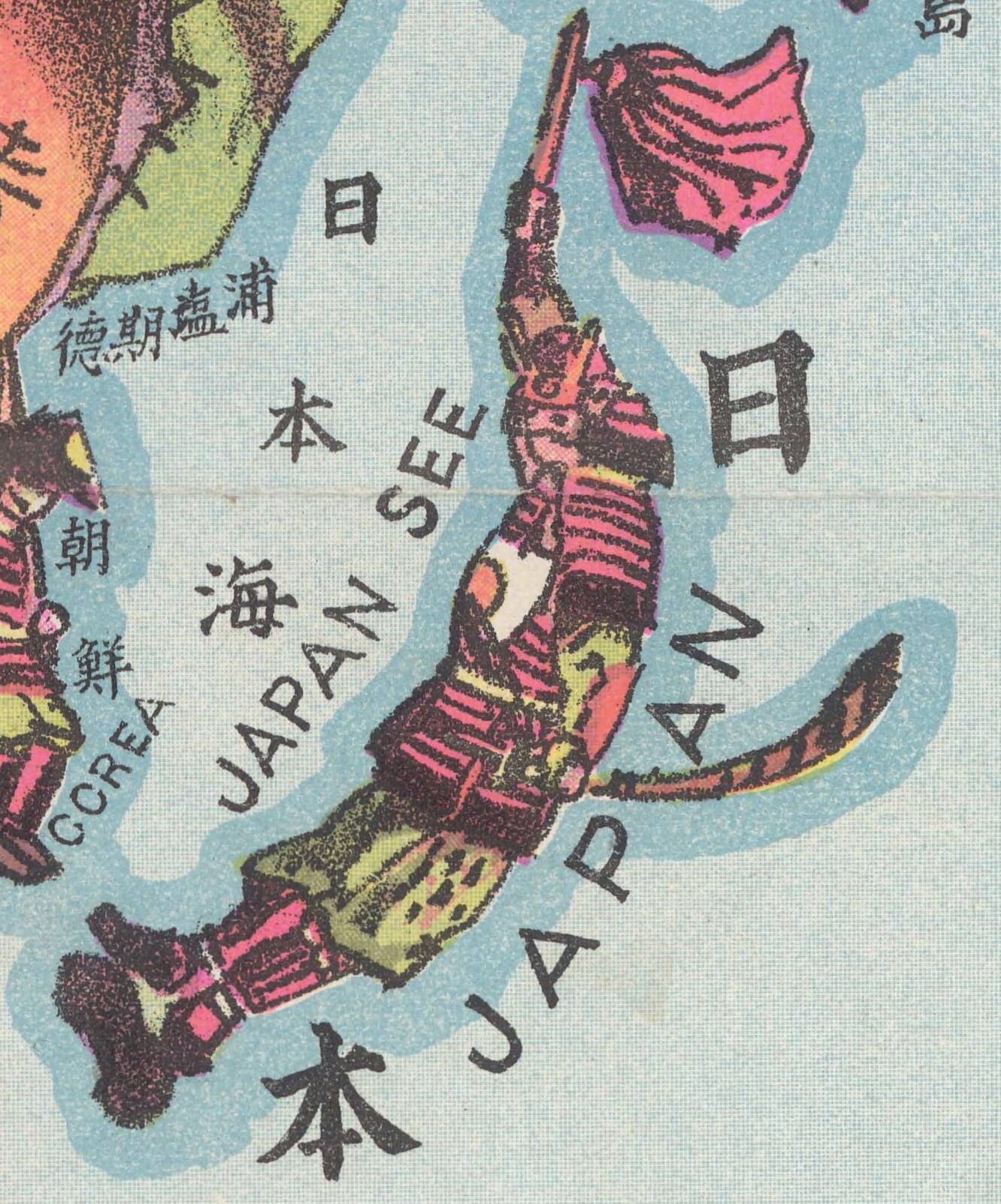
Индия и Бирма соединены вместе и представлены в виде слона, а Аравия изображена лошадью. Единственные человеческие образы на карте — это Америка, две вялые женские фигуры, представляющие Нубию и Триполи (т.е. Ливию), а также Япония и Корея. Япония — это большой самурай с мечом, а Корея (которая была официально колонизирована Японией четырьмя годами ранее) представлена в виде крошечной безоружной фигурки, сидящей в покорной позе перед самураем. Карта снабжена надписями на японском и английском языках, с некоторыми очаровательными ошибками в английском ("humoros", "Japan See" и т.д.).
The Illustration of the Graet (sic) European War. 1914. Detail: India

The Illustration of the Graet (sic) European War. 1914. Detail: Turkey
Pub Note:
"Published just after the start of the First World War, on 13 September 1914, and subtitled in English ‘The Illustration of the Graet European War’ [sic], this map was designed and printed by Tanaka Ryōzō (1874-1946), who ran a print shop in central Tokyo and later became well known for producing prints of works by prominent modern woodblock artists. Although it is described as ‘map of the world’, it is really a map of Europe, Asia and part of North Africa. The US is interestingly shown as a man in a top hat looking at Asia through a telescope from a small patch of land that appears to be somewhere in the middle of the Pacific. The rest of North and South America and all of Australia and New Zealand are missing. The colourful and decorative map cleverly depicts each country as an animal, or more rarely as a human figure, giving an intriguing insight into Japanese perceptions of the state of the world (and some Japanese prejudices about neighbouring countries!) at the start of World War 1. Under the terms of its alliance with Britain, Japan had joined the war on the side of the Allies, and its sense of Germany and Turkey as enemies is reflected in the depiction of Turkey as a tiger and of Germany as a wild boar wielding a sabre, which is being pierced by arrows labelled ‘France’, ‘Gritain’ [sic], ‘Japan’ and ‘Russia’. But the other main Central Power, the Austro-Hungarian Empire, is represented by a rather blurry image of dog, suggesting that perhaps the map’s illustrator had little clear impression of the nature of the Hapsburg Empire. Meanwhile France seems to have been subsumed into the German boar, while Britain is a shachihoko – a mythical creature with the body of a carp and the head of a tiger, commonly used as a decoration on the roofs of Japanese buildings. (Ireland is either missing from the map, or is perhaps meant to be represented by one of the shachihoko’s fins). The dominant figures on the map are Russia – depicted as a very large and lethargic bear smoking a pipe – and China – shown as pig which is rather enigmatically staring at a barometer. Both figures suggest powerlessness and inertia. India and Burma are joined together and represented as an elephant, while Arabia is depicted as a horse. The only human images on the map are America, two languid female figures representing Nubia and Tripoli (i.e. Libya), and Japan and Korea. Japan is a large sword-wielding samurai, while Korea (which had been formally colonised by Japan four years earlier) is represented as a tiny unarmed figure sitting in a submissive position in front of the samurai. The map is labelled in both Japanese and English, with some rather charming mis-spellings in the English (‘humoros’ and ‘Japan See’ etc.) " (Asia Bookroom, 2022)
The Illustration of the Graet (sic) European War. 1914. Detail: China

The Illustration of the Graet (sic) European War. 1914. Detail: America
The Illustration of the Graet (sic) European War. 1914. Detail: Japan
27 января 2023, 21:16
0 комментариев
|
Партнёры
|
| tehne.com © 2011—2026 Все права защищены. |
Если у вас есть интересная для нас
информация – пишите на почту info@tehne.com |
|
Сайт разработан
Лабораторией дизайна «Pixel»© 2012 |
Комментарии
Добавить комментарий